Alabama
Alaska
Arizona
Arkansas
California
Colorado
Connecticut
Delaware
Florida
Georgia
Hawaii
Idaho
Illinois
Indiana
Iowa
Kansas
Kentucky
Louisiana
Maine
Maryland
Massachusetts
Michigan
Minnesota
Mississippi
Missouri
Montana
Nebraska
Nevada
New Hampshire
New Jersey
New Mexico
New York
North Carolina
North Dakota
Ohio
Oklahoma
Oregon
Pennsylvania
Rhode Island
South Carolina
South Dakota
Tennessee
Texas - East
Texas - West
Utah
Vermont
Virginia
Washington
West Virginia
Wisconsin
Wyoming
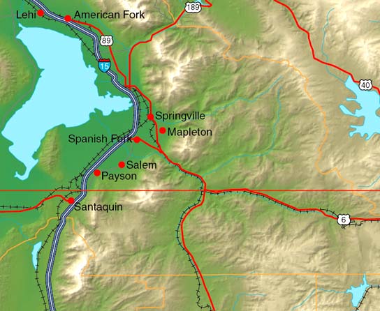
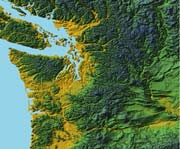
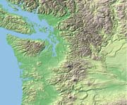
USA Relief provides a set of 4 full color shaded relief maps along with one grayscale relief map. These raster relief maps constitute a highly detailed topographic base over
which the EPS vector data features such as coastlines, rivers, interstate and major road systems, railroads, county, state and international borders, town locations, town names text, latitude and longitude grids, are overlayed. The map images in this collection have been computed from the USGS 3 arc second, gridded elevation database and generated at a scale of 100 meters per pixel - giving over 4 Gb of terrain imagery per color style for the entire USA.
Coverage & Organization
The collection includes an individual portfolio of maps for each of the 50 US states within the entire continental United States and for Alaska and the islands of Hawaii. A portfolio may be sized from 20 Mb to over 200 Mb depending on the physical size of the state. The collection is grouped in contiguous state sets which ship on individual DVD's complete with HTML instructions.
Image size
Each state map varies in size - at 300 dpi, the base relief image for Indiana measuring 6,000 X 6,000 pixels produces an image 20 by 20 inches, or an umcompressed file size of 108 Mb. As a rule of thumb to calculate the image dimensions, the distance across the state in miles can be multiplied by 16 to give the approximate pixel size, or 1,200 pixels per degree of latitude or longitude - in both cases, multiply the height by the width by 3 to give the file size of the resulting image. For a full specification for each of the 50 state maps, see the detailed state map specification page which shows degree boundaries for each state, number of one degree quads used to make up the map, width and height in pixels and in inches at 300 dpi, and full bitmap image size in megabytes. Remember to double the image size for desktop or exhibition printing at 150 dpi or for screen use in multimedia or web quadruple the image dimensions - this allows small areas to be viewed.
Format
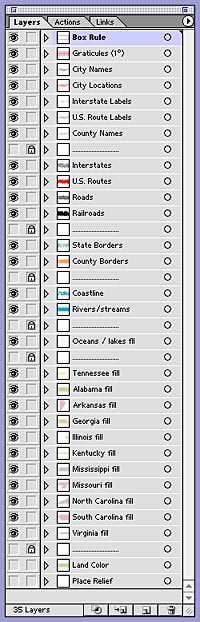
The 5 relief maps are in high quality JPEG format and the vector overlays are provided in a layered (see layers palette to the right) and editable EPS file format, all delivered on CD-ROM. The vector maps may be edited giving clients the option to change line widths and color, font styles and colors, and allowing the placement of any of the 5 relief maps as the bottom layer. Layers themselves may be switched on or off at will and the sequence may be altered to suit any specific circumstances that you wish to portray. Detailed user instructions using Illustrator and Photoshop are given on this web site and on the USA Relief map CD-ROM.
Map Scale
The scale of the relief map images at 72 dpi is 1:280,000. At 300 dpi this would be equivalent to approximately 1:1,000,000. The base relief images are generated from 100 meter USGS DEM data presenting exactly one pixel per 100 meter of terrain or 16 pixels per mile. A map printed at 300 dpi would show a scale of 18.75 miles or 30 km per inch, at 200 dpi 12.50 miles or 20 km, at 150 dpi 9.4 miles or 15 km, at 100 dpi 6.25 miles or 10 km, and at 72 dpi this would be show 4.50 miles or 7.20 kilometers per inch.
Projection & Map units
Geographic projection; each map extends to the next nearest degree line around the state and includes a longitude / latitude grid at 1º interval on its own EPS layer.
Applications
The grayscale relief map can either be pre-colored or manipulated in Adobe Photoshop, or tinted by applying a colored layer in Adobe Illustrator. Use of these maps is not limited to the applications mentioned here, but can be used with any Image Editor, Graphics or Layout software capable of opening or importing JPEG bitmap and EPS vector files.
Color and Styles
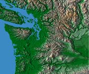
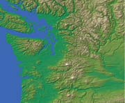
Four color relief map styles shown below are RGB 24 bits per pixel, 300 pixels per inch. The color schemes feature a low contrast (shown in full scale above), a strong high-contrast look, a natural look and a standard cartographic map elevation color scheme. In addition, one grayscale relief map is supplied in 8 bit Grayscale, 300 pixels per inch; this is provided for designers to generate color scheme to match or who wish to apply their own custom house styles to the relief maps.

Cartographic Style
Natural Look Style
High-Contrast Style
Low-Contrast Style
Ordering options / More Info
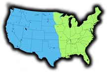 The USA Relief collection of 50 US states exceeds 8 GB and 400 files. Each state available separately and is priced at $19 for immediate download. The entire USA State collection is available on Flash drive and priced at $190; separate East and West US collections on Flash drive are priced at $95 each. The division between East and West follows approximately the 95º line of longiitude or the Mississippi River;
East DVDR:
Alabama
Arkansas
Connecticut
Delaware
Florida
Georgia
Illinois
Indiana
Iowa
Kentucky
Louisiana
Maine
Maryland
Massachusetts
Michigan
Minnesota
Mississippi
Missouri
New Hampshire
New Jersey
New York
North Carolina
Ohio
Pennsylvania
Rhode Island
South Carolina
Tennessee
Vermont
Virginia
West Virginia
Wisconsin
West DVDR:
Alaska
Arizona
California
Colorado
Hawaii
Idaho
Kansas
Montana
Nebraska
Nevada
New Mexico
North Dakota
Oklahoma
Oregon
South Dakota
Texas - East
Texas - West
Utah
Washington
Wyoming
Click here to Request more information or click here to place an Order for USA Relief by State or by Collection.

USA Relief Maps ~ Digital Wisdom Inc ~ PO Box 11 ~ Tappahannock VA 22560 ~ USA
800-800-8560 | 804-443-9000 | Email
© Digital Wisdom, Inc. - PL
Any comments or problems with this site? Please let us know - thank you!